By Dar Danielson (Radio Iowa)
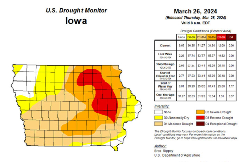
DNR Hydrologist Tim Hall says the recent snow and rains have helped push back some of the drought conditions in the state.
“The statewide average over the last seven days, three times the normal rainfall for that seven-day period. And for the month of March, we’re ahead of normal. And so those things are all reflected in the U-S Drought Monitor this week,” Hall says.
Northeast Iowa remains the driest area of the state, but the picture is better than last week. “Almost 20% of the state was designated as D-3 extreme drought. And now that’s down to 12%,” he says. Hall says it is good to see the dry weather turnaround in March. “Every month that goes by between March and April in May and June, the monthly precipitation averages go up. So that’s why it’s really critical when we get above normal rainfall in March, because March is a pretty wet month, and even more so for April and even more so for May,” Halls says.
He says the past few years a promising start to spring didn’t pan out. “We’ve seen really encouraging early spring and late winter rainfalls, but then the tap has been shut off. And we’ve missed out on April May and June rainfalls over the past few years,” he says. “So we’re really hoping that this will set a trend that will allow us to see above normal rainfall in April and then May and then June. And that’ll go a long ways toward getting some significant areas of drought wiped off the map here.”
The Drought Monitor shows the areas of the state not reporting any drought have gone from just more than two percent to now just under ten percent.


