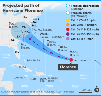
Hurricane Florence made landfall Friday at 7:15am near Wrightsville Beach, North Carolina with winds of 90 mph. Despite being downgraded again late Thursday night, this time to a Category 1 storm, Florence is projected to bring “hurricane-force winds and life-threatening storm surge” as it makes its way on a southwest trek along the Carolina coasts. Florence spent Thursday crawling toward the Carolina coast at 5 to 6 mph – hardly faster than the average person’s walking speed of 3.1 mph – but the storm’s relentless rain had already resulted in serious flooding in low-lying areas and its gusting winds knocked out power for thousands of people in North Carolina. There were water rescues underway in New Bern early Friday morning, the city shared on Twitter. Don’t be fooled by Florence’s Category 1 status, either, CNN meteorologist Derek Van Dam said. “Focus that this storm is here to stay,” the waterlogged Van Dam said during a live broadcast Thursday. NWS meteorologist Brandon Locklear said North Carolina could see the equivalent of eight months of rain in the span of two or three days.
It’s the storm surge, or the rising of the sea level, that pushes water ashore and leads to flooding. The forecast for Florence includes storm surge up to 11 feet in some areas. During CNN’s live coverage Thursday night, storm chaser Mike Scantlin said, “Water kills more people than every other weather phenomenon – combined.” Extreme winds mean power outages. More than 415,000 customers were without power, mostly in North Carolina, as the eye of Hurricane Florence went ashore near Wilmington and began its slow trek inland and along the coast. For updates, go online to www.ncdps.gov/florence.


