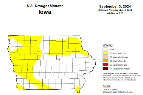
DES MOINES — Consistent above-normal rainfall during the summer months slowed in August, leading to a return of dry conditions, according to the latest Water Summary Update.
August’s preliminary statewide precipitation was 3.20 inches, or 0.93 inches below normal. At the end of August, Iowa’s Drought Plan showed overall drought conditions have remained mostly stable for the state. However, the decrease in precipitation has led to a return of dry conditions.
The U.S. Drought Monitor (USDM) shows nearly 40 percent of the state carrying abnormally dry designations, with areas of western and northeast Iowa seeing the biggest change. This trend could turn worse if the dryness of August extends into the fall months.
Temperatures for the month were near normal, with the summer months of June, July and August averaging 72.0 degrees statewide. The preliminary precipitation totals for that same period were 13.75 inches, or 0.19 inches above normal.
Despite the dry conditions, the state has received more than 38 inches of rain in the past 12 months, which is a foot more than what the state saw between September 2022 and August 2023.
“The Iowa Drought Plan rates statewide drought conditions as normal, although the month of August was drier than usual. As we move into September we would expect to get less than an inch of rain per week, with average rainfall continuing to drop through the rest of the year. It is important that we continue to see normal precipitation through the fall and into the winter months,” said Tim Hall, the DNR’s Hydrology Resources Coordinator. “We are to the point now where rainfall will begin to build up next year’s soil moisture and groundwater, so a wetter than normal fall would be great to see. If conditions remain dry, we could have issues going into 2025.”
For a thorough review of Iowa’s water resource trends, visit


