By Dar Danielson (Radio Iowa)
Smoke from the Canadian wildfires is showing up over of Iowa again. National Weather Service Meteorologist Dylan Dodson, says it’s most notable in one area.
“So we’ve kind of got a little bit overhead currently, mainly over the western parts of the state. You can see it on satellite, just kind of this faint kind of like a hazy look to it,” Dodson says. Dodson says things are different from July when the smoke was clearly visible across the state and made an impact on the sunset and sunrise.
“It’s not nearly what we’ve seen previously this year, not seeing much of anything as far as visibility reductions or anything like that,” he says.
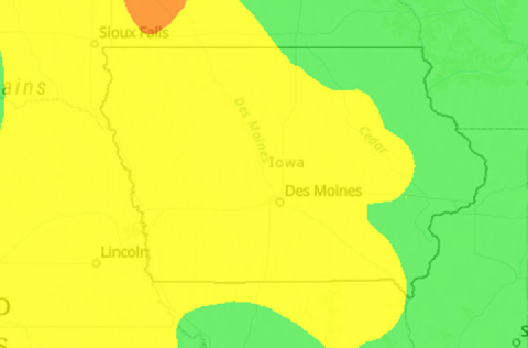
The DNR Air Quality monitor is not showing any air that is at the unhealthy level in the state. The air is reported at the moderate level for two-thirds of the state, which is a level below healthy.
The forecast is still showing that hot weather will be more of a concern this weekend than the smoke. “Fortunately it won’t be near as bad as our last round of heat that we had,” Dodson says. “Dewpoints will be a little bit lower.” Lower dewpoints mean the “feels like” temperature is lower. Dodson says the actual air temperature is something to take note of.
“We’re still looking at some temperatures, high temperatures in the mid to upper 90s. Looks like right around the mid-90s Saturday and Sunday,” he says. “Definitely looking at some more heat again, and that’s looking to last into early next week at least.” One thing that is still not in the forecast is precipitation, as Dodson says it remain dry into next week.


